

SAN ANGELO, TX — The National Weather Service warned Tuesday of a threat of heavy rainfall and possible flash flooding across West Central Texas from Wednesday into Thursday night as showers and thunderstorms move through the region.
Scattered to numerous storms are expected to begin affecting northern and western parts of the area Wednesday before a focused corridor of rain shifts southeast Thursday with the arrival of a cold front, according to the NWS San Angelo forecast office. There is potential for rainfall to be heavy, bringing a risk of at least localized flooding and flash flooding.
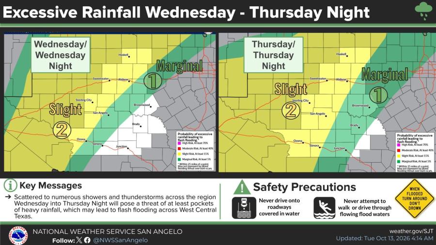
Forecasters placed portions of the region under a slight risk (at least 15% probability) and a marginal risk (at least 5% probability) of excessive rainfall leading to flash flooding for both Wednesday and Thursday. Areas near Abilene, Sweetwater, San Angelo and points farther west and northwest face elevated chances, while risks decrease toward the southeast.
Temperatures will remain very warm through Wednesday, with highs generally in the low to mid-90s across cities including Abilene, San Angelo, Ballinger and Haskell. A strong cold front is forecast to push south across the area Thursday afternoon and night, bringing much cooler conditions Friday into the weekend. Friday highs are expected to fall into the upper 60s to low 70s, with gusty north winds. Lows will drop into the upper 40s to mid-50s in many locations by the weekend.
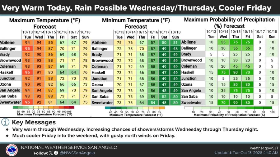
Precipitation probabilities rise sharply Wednesday and Thursday for much of the area. Several locations, including Abilene, Haskell, Ozona, San Angelo and Sweetwater, show peak chances of 70% to 90% for rain during that period before probabilities drop significantly by Friday and Saturday.
NWS safety guidance advises residents never to drive onto roadways covered in water and never to attempt to walk or drive through flowing floodwaters.



Subscribe to the LIVE! Daily

Required
Comments
Listed By: Wiley Coyote
Hope we get that 100 year flood in our water shed this time🤔
- Log in or register to post comments
PermalinkPost a comment to this article here: